Metric Abbrevation and Data Explanation for the iLit4UrbanGreenSpace Web App
Landscape Metric Abbreviations
| Metric | Abbreviation | Metric Definition (citation) | Equation |
|---|---|---|---|
| OVERALL GREEN SPACE AREA: | |||
| Percentage of Landscape | PLAND | The percentage of the landscape made up of green space (McGarigal et al. 2012). | 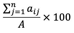 |
| Area | Area | Area of green space in squared units (McGarigal et al. 2012). |  |
| GREEN SPACE PATCH AREA: | |||
| Mean Patch Area | PA | The average area of all green space patches in a landscape (McGarigal et al. 2012). |  |
| Largest Patch Index | LPI | The percent coverage of the largest patch in a landscape (McGarigal et al. 2012). | 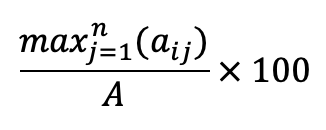 |
| GREEN SPACE AGGREGATION: | |||
| Number of Patches | NP | The number of green space patches in a landscape (McGarigal et al. 2012). |  |
| Patch Density | PD | The number of green space patches in relation to the total landscape area (McGarigal et al. 2012). |  |
| Euclidean Nearest Neighbor Distance | ENN | The average distance between a green space patch and the nearest neighboring green space patch (McGarigal et al. 2012). |  |
| Landscape Division Index | DIVISION | The probability that two randomly selected green space cells are not part of the same patch (McGarigal et al. 2012, Jaeger 2000). | 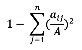 |
| Splitting Index | SI | The number of patches if all green space patches would be divided into equally sized patches (McGarigal et al. 2012, Jaeger 2000). |  |
| Landscape Shape Index | LSI | The ratio between the actual edge length of green space patches and the hypothetical minimum edge length of green space patches (McGarigal et al. 2012, Patton 1975). | 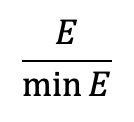 |
| Patch Cohesion Index | PCI | The connectedness of green space patches determined by the perimeter, area, and number of cells (McGarigal et al. 2012, Schumaker 1996). |  |
| Aggregation Index | AI | The number of like adjacencies divided by the theoretical maximum possible number of like adjacencies for green space (McGarigal et al. 2012, He et al. 2000). |  |
| Interspersion & Juxtaposition Index | IJI | The intermixing of green space patches determined by the number of unique adjacencies with green space patches (McGarigal et al. 2012). | 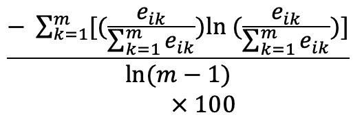 |
| Clumpiness Index | CLUMP | The proportional deviation of the proportion of like adjacencies compared to what would be expected with a spatially random distribution (McGarigal et al. 2012). | 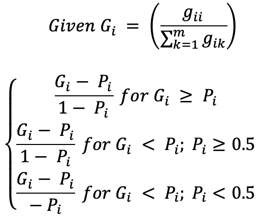 |
| GREEN SPACE SHAPE: | |||
| Width/Lengthy | Width/Length | The width and length of green space patches. | NA |
| Mean Shape Index | SHAPE | The mean of the ratio between the actual perimeter of green space patches and the hypothetical minimum perimeter of green space patches for all patches (McGarigal et al. 2012, Patton 1975). | 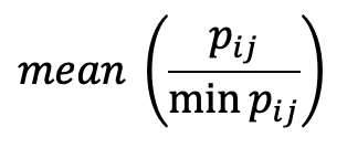 |
| Mean Contiguity Index | CI | The mean of the spatial connectedness of all green space patches (McGarigal et al. 2012). |  |
| 3D GREEN SPACE: | |||
| Height | Height | The height of green space. | NA |
| Visibility | Visibility | The distance at which the light provided by a spotlight was no higher than the background light levels (Fang and Ling 2003). | NA |
| Depth (Vertical) | Depth | The depth of vegetation on a vertical green wall. | NA |
| WHERE: | |||
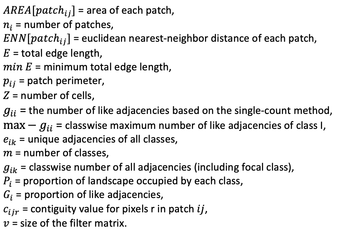 |
|||
Data Explanation
See below for a brief explanation of some of the data fields used in our web app whose meaning may not be easily conveyed by their names.
| Data Field | Brief Explanation |
|---|---|
| Google Scholar Page of Paper |
This is the Google scholar page of the paper. On the map pop up (when clicking a paper point on the map, the popped-up info box) and on the data table, which is at the bottom of the web app, there is a clickable URL that will direct you to the paper’s Google Scholar page. This is where readers can find new papers citing each paper, so new paperas can be easily tracked. Note that if a paper does not have a Google Scholar page, we provide the ResearchGate link of the paper, if available. |
| Cited by URL |
Not every paper seems to have a Google Scholar page. However, if a paper has at least one citation, it will have a Google Scholar Cited by URL to allow our users/readers to easily track new publications citing the paper. |
| Study Area Country |
Names of the country or countries that the research was conducted in. |
| Study Area City |
Names of the city or cities that the research was conducted in. |
| Study Area City Count |
The count of the number of cities included in the research. Ranges from 1 to 10+ (this data is used to create the map legend). |
| Metric Tool |
The name of the tool used to calculate landscape metrics. If the authors calculated the metrics without a previously created tool, “no tool” is input. |
| Metrics |
Names of the metrics used to quantify the composition and configuration of urban green space. An abbreviation key, full definitions, and equations are available here and in the SI of the article. |
| Green Space Type |
Type of green space examined by the research. When possible, exact nomenclature from the article is used, however, forests and tree research was simplified to “trees”. |
| Green Space Data Source |
Data source for the green space variable used in the research. |
| Green 2D/3D |
Was green space measured in 2D, 3D, or both? This variable is a reflection of the input data, an example of 2D is satellite imagery while an example of 3D is LiDAR data. |
| Noise Measurement |
How was noise quantified? |
| Noise Variable |
What was the noise variable measured? |
References
Here we provide the references cited in the Landscape metrics above.
| Fang, C.-F., & Ling, D.-L. (2003). Investigation of the noise reduction provided by tree belts. Landscape and Urban Planning, 63(4), 187–195. https://doi.org/10.1016/S0169-2046(02)00190-1. |
| He, H. S., DeZonia, B. E., & Mladenoff, D. J. (2000). An aggregation index (AI) to quantify spatial patterns of landscapes. Landscape ecology, 15(7), 591-601. |
| Jaeger, J. A. (2000). Landscape division, splitting index, and effective mesh size: new measures of landscape fragmentation. Landscape ecology, 15(2), 115-130. |
| McGarigal, K., Cushman, S.A., & Ene, E. (2012). FRAGSTATS v4: Spatial Pattern Analysis Program for Categorical and Continuous Maps. Computer software program produced by the authors at the University of Massachusetts, Amherst. Available at the following web site: https://www.umass.edu/landeco/ |
| Patton, D. R. 1975. A diversity index for quantifying habitat "edge". Wildl. Soc.Bull. 3:171-173. |
| Schumaker, N. H. (1996). Using landscape indices to predict habitat connectivity. Ecology, 77(4), 1210-1225. |